Using an outdated topographic (topo) survey in a planning submission means the proposal is assessed against the wrong “existing” site. That is a common reason drawings get challenged, revised, or refused. The issue is rarely the age of the file on its own, it is whether levels, boundaries and site features still match what is on the ground and whether they are tied to a consistent datum. If the baseline is wrong, everything built on it (plans, sections, access, drainage, streetscape) becomes harder to evidence. This article shows how to spot problems quickly, when a refresh is sensible, and how to brief a survey so your planning set stays coherent.
Existing Baseline Planners Rely on
Planners, neighbours and consultees judge proposals by comparing them to the current situation. If the topo does not reflect what is there now, your sections, heights, visibility and drainage assumptions can be wrong before design even starts. In planning terms, “outdated” means the survey is no longer reliable for today’s site conditions or cannot be checked. The usual consequence is avoidable redesign and rework, sometimes late enough to miss a target submission or committee date.
What “outdated” means in planning terms
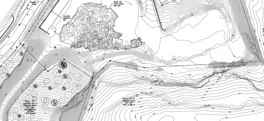
A topo is likely to be a risk if it predates material changes such as groundworks, resurfacing, new kerbs, moved fences, or trees removed or planted. It is also problematic where heights are not tied to a clear, consistent datum (for example AOD), or where the drawing note and the plotted levels do not align. Coverage is another common failure point, for instance where the survey does not extend to neighbour thresholds, the carriageway, verges, or access points that the proposal depends on. Finally, if there is no survey date, control information, or clear authorship, it becomes difficult for the design team to stand behind the baseline.
Site changes that quietly invalidate older topo data
Minor site changes can have major knock-on effects. Resurfacing can raise a drive by 80 to 120 mm, a new kerb can alter drainage falls, and moved fences can change the apparent developable area. Neighbours’ extensions can affect overlooking lines, while tree growth can bring canopies and RPAs into conflict with design assumptions. Utility covers are often lifted or replaced, and highway layouts can change through re-marking, bays, or stop locations. Each change may look small, but together they can undermine sections, gradients and sightlines.
Designing to the wrong ground and datums
A topo that is not anchored to a dependable datum creates quiet errors across the whole drawing set. “Ridge +X m AOD” or “FFL +Y m” becomes a guess, and that affects roof height comparisons, step-free access design and drainage gradients. Planning officers do not need surveying terminology, but they do need a consistent baseline that your plans, elevations and sections all reference in the same way.
Where Refusals and Objections Show up
When the base information is shaky, the same issues keep surfacing: drawings that do not reconcile, relationships that are misrepresented, and technical claims that cannot be evidenced. A practical rule is simple, if the topo cannot support the critical planning arguments, fix it before the application goes in. A survey refresh early is usually faster than cycling through case officer queries and neighbour-led challenges.
Levels and sections that don’t reconcile
Inconsistent geometry is one of the quickest ways to lose confidence in a submission. Common red flags include existing and proposed sections that disagree with each other, ridge and eaves lines that do not match the street elevation, and gradients that do not achieve the stated access approach. Once drawings stop adding up across the set, officers and consultees tend to question everything else.
Neighbour relationships assessed on false heights and boundaries
Daylight, sunlight, overlooking and massing rely on distance and relative height. If the boundary position is wrong, or neighbour finished floor levels are assumed rather than surveyed, privacy and overshadowing arguments weaken quickly. This is also where objections can escalate, because neighbours or their agents may challenge drawings with photos, basic measurements and site observations that appear to contradict the application plans.
Access, visibility and drainage arguments that can’t be evidenced
Highways responses often turn on accurate kerb lines, carriageway edges and visibility splay positions. Drainage layouts depend on real falls and, where relevant, invert levels. If spot levels are sparse, outdated, or not linked to a clear datum, statements like “it will work on site” are unlikely to satisfy planning reports or technical comments.
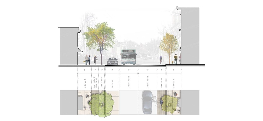
The Evidence Package that Holds up for Existing-Building Projects
For alterations, infill and change-of-use projects, the strongest submissions combine a current topo with the right measured context so the drawing set reads as one coordinated package. Good practice is consistency: the same baseline, the same datum, and clear traceability from what was surveyed to what is shown.
Planning-ready topo deliverables and formats
Planning teams typically need clean 2D CAD (DWG/DXF) with sensible layering for boundaries, kerbs, walls, trees and observed utilities, supported by PDFs that match the CAD. Levels should be concentrated where decisions sit, including thresholds, ridges and eaves, kerbs, channels, gullies and key changes in gradient. The drawing should also state the datum and coordinates used, along with the scale, north point, legend and the survey date.
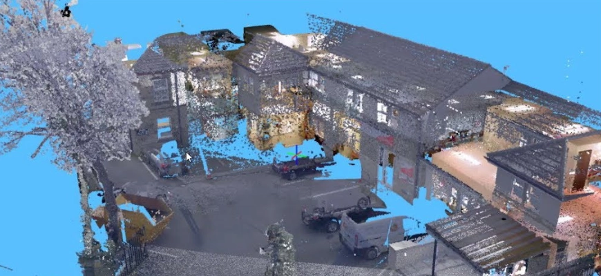
When you need measured building survey or laser scan context
Where proposals interact with façades, rooflines or internal levels, a measured building survey helps align sections, streetscapes and height relationships. Laser scanning can be useful on complex elevations and eaves where traditional capture is slower or more prone to missed detail.
A quick primer on Measured building surveys is here: https://survey2plan.co.uk/what-is-a-measured-building-survey/
Practical limitations that affect reliability
Survey data is only as good as the conditions on the day. Vegetation can hide kerbs, parked vehicles can block gullies and channels, and overhanging canopies can limit sightlines. If parts of the context are inaccessible (including third-party land), some elements may be inferred or omitted. Strong survey drawings make those limitations clear, so the design team and planners understand what is observed versus assumed.
Key Takeaways Before You Submit
Planning decisions rely on the “existing” baseline. If the topo is outdated, the proposal becomes harder to assess and easier to challenge. “Outdated” is not just about age, it is about change, on site, at the boundary, or in the immediate context. Most delays trace back to levels, trees, boundaries and highways context being wrong or incomplete.
If you are preparing to submit, or responding to a validation query, send the site location, building type, intended use, required outputs and timeframe. We will advise whether your topo is ready, or what needs updating to keep the application moving.